Using Information Resources, continued
You can find different types of maps inside atlases. You can use the different maps for different purposes. Let’s see what some of them look like.
Physical Maps
A physical map shows the geographical features of a place, such as bodies of water and landforms.
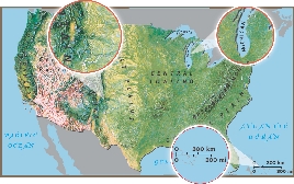
Mapmakers often use techniques that make mountains look like they are rising off the page.
Landforms, like mountains or lakes, are often labeled.
The scale shows that this distance on the map is equal to 300 miles on land.
Product Maps
A product map uses pictures and symbols to show where products come from or where natural resources are found.
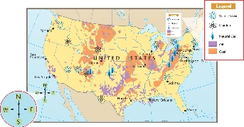
 Water Power
 Uranium
 Natural Gas
 Oil
Oil Coal
Coal
Legend
The compass rose shows the directions north, south, east, and west.
The map legend shows what the pictures stand for.