Language and Content
Success in Social Science
Learn About Cities

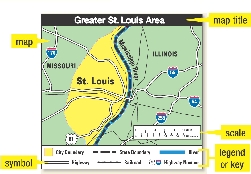
map
map title
scale
symbol
legend or key
 City Boundary
 State Boundary
 River
River Highway
 Railroad
 Highway Number
Use the scale to measure the distance between places on a map.

centimeter
inch
12 inches = 1 foot
3 feet = 1 yard
1,760 yards = 1 mile
Listen to the article and study the chart. Then do the Review.
• How and why has St. Louis changed over the years?
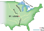
Saint Louis, Missouri, is located near where the Mississippi and Missouri Rivers meet. Fur traders settled in the area in 1764 because boats could easily travel there. Soon the town became the starting point for explorers, fur trappers, and settlers traveling west.

Rivers Connected to the Mississippi
 City
City River
River
In the 1850s, the railroads joined St. Louis with other large cities like Chicago.
Companies could easily ship goods in and out of the city. From 1840 to 1870, St. Louis’ population increased by almost 300,000 people!


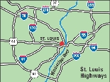
Highways and bridges across the Mississippi River made it even easier to get to St. Louis. Today St. Louis is one of the leading railway and trucking centers in the United States.
1. Check Your Understanding Why did the fur traders choose to settle in the St. Louis area?
2. Vocabulary Name some highways that go to St. Louis.
3. Use Maps What does the dot symbol on the map of rivers mean?